‘The most terrible camp’: After 80 years, cruelty of SS site on UK soil revealed
INTERVIEW INMATES WERE MOSTLY EAST EUROPEANS, WITH MANY FRENCH JEWS
Archaeologists publish in-depth survey highlighting the historical importance of the oft-overlooked Lager Sylt, as well as the physical and psychological torture of its inmates
")
")
")
")
")
")
LONDON — British archaeologist Caroline Sturdy Colls compares her work on the sites of Nazi atrocities to a police inquiry.
“This is an investigation into historic crime, but crime that still has relevance for people today,” explains the Staffordshire University professor. “You wouldn’t conduct a police investigation only looking at witness testimony.”
For Sturdy Colls, who has worked on Holocaust and genocide sites throughout Europe, including Treblinka, it is the bringing together of physical evidence and witness testimony which offers the opportunity to find “new evidence and new perspectives on the nature of these crimes.”
Alderney is in one of the small clusters of islands — an archipelago which includes Jersey, Guernsey, and Sark — which lie in the English Channel off the coast of Normandy. Semi-independent, they were nonetheless the only part of the British isles to be occupied by Germany during World War II.Alongside a team from the university’s Center of Archaeology, Sturdy Colls has just completed a decade-long investigation into one of the least-studied scenes of Nazi barbarism: Lager Sylt, a slave labor and concentration camp on the island of Alderney.
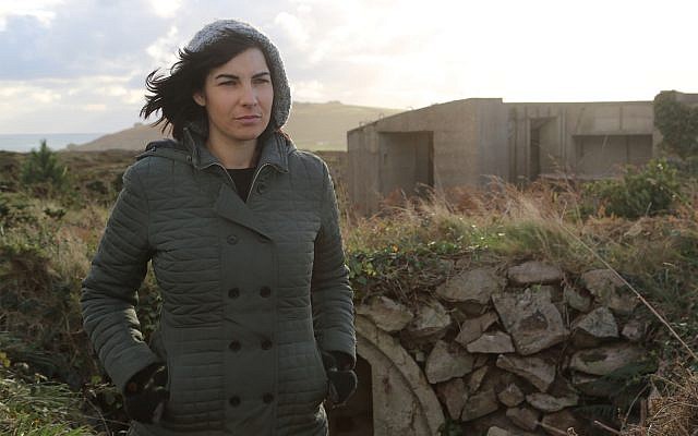
Illustrative: Caroline Sturdy Colls, a renowned forensic archaeologist, in the 2019 documentary, ‘Adolf Island.’ (Snap TV via JTA)
The result of the Staffordshire University team’s research is published in April’s edition of the academic journal Antiquity. It brings together declassified aerial photographs, archival accounts, and a range of other non-invasive techniques — such as ground-penetrating radar, and light detection and ranging surveys (LiDAR) — to produce the first investigation of Sylt since a British government inspection in 1945. It is also the first to use archaeological methods.
‘The most terrible camp’
Sylt is near-unique. It is one of only two concentration camps to have been sited on British soil. The other — Lager Norderney (not to be confused with the island of Norderney off Germany’s northern coast) — was one of four forced labor camps constructed on Alderney after the island was occupied in June 1940.
Built in 1942, Sylt was originally one of the smaller camps. But a year later, Sylt, together with Norderney, was taken over by the SS Death’s Head Unit. It became a satellite of Neuengamme, expanded rapidly in size, and was turned into a concentration camp. Sylt swiftly earned a well-deserved reputation as “the most terrible camp,” as a former Alderney prisoner later testified.
The French prisoners dubbed Alderney “le rocher maudit” — the accursed rock
Its inmates were mostly East Europeans, although there was also a large contingent of French Jews. The French prisoners dubbed Alderney “le rocher maudit” — the accursed rock — underlining the brutality of the wind-swept, sea-beaten and remote island. Its prewar civilian population of 1,400 people had been evacuated by Britain when, deeming them too difficult to defend, it pulled out of the Channel Islands after the fall of France in June 1940.
For Hitler, these solitary prized British possessions were — as Nazi propaganda would have it — the “last stepping stone before the conquest of mainland Britain.” But Alderney also had an important strategic value. As part of the “Atlantic Wall” fortifications, it was intended to protect the sea channels around Cherbourg, provide the Luftwaffe with anti-aircraft cover, and deny the Allies a potentially useful staging post for the opening of the feared Western Front.
From early 1942, Alderney thus became the scene of massive construction — of tunnels and bunkers, gun emplacements and artillery batteries, roads and a railway line — which would leave it the most fortified of the Channel Islands. Sylt’s slave laborers, together with those of Alderney’s other camps, were put to work on this massive construction effort.
It was the number of sites connected to the occupation on the small island — which is a mere three miles long and half a mile wide — which, in part, sparked Sturdy Colls’s interest.

Plans showing: A) the function of each structure; and B) remnants recorded during archaeological
investigations. (Centre of Archaeology, Staffordshire University/ via Antiquity Publications)
investigations. (Centre of Archaeology, Staffordshire University/ via Antiquity Publications)
“There are publications about this and there have been a lot of testimonies since the war but a lot of them don’t cover the forced and slave labor perspective and, apart from investigations in the immediate aftermath of the war, nobody has focused on the physical traces of these sites,” she tells The Times of Israel.
At Sylt her team used a series of non-invasive techniques which she has developed and deployed at other sites in Europe, particularly those connected to the Holocaust.
“What this means, in a broad sense, is that we can investigate the landscape — everything from the entire landscape at a macro level of Alderney down to very minute in-field objects and items — without disturbing the ground in any way,” she says.
“The crucial thing,” Sturdy Colls says, “is really using those techniques in combination and then bringing all of that data together with aerial photographs, witness testimony, maps, [and] plans, and essentially layering them to be able to try and determine what some of these surface and buried features might be.”
A taboo subject
But the work has taken place against a complex backdrop. In a bid to disguise their crimes, the SS demolished much of the camp in 1944. That effort, combined with the fact that, for many years, the presence of concentration camps on British soil was something of a taboo subject, meant that Sylt was often dismissed as having been “destroyed” or “dismantled.”
When the island’s parliament, the States of Alderney, debated whether to include Sylt in its register of historic buildings and monuments in 2015, for instance, one committee member suggested: “If there were buildings or something there worth conserving, I might have a different opinion; but there is nothing, apart from a broken old wash trough […] and a load of brambles.”

Photo of Sylt Concentration Camp on the island of Alderney, after Nazi surrender, May 1945. (Courtesy of the
Trustees of the Royal Air Force Museum/ via Antiquity Publications)
Trustees of the Royal Air Force Museum/ via Antiquity Publications)
One of the study’s most important findings, the Antiquity paper notes, was to demonstrate that “considerable traces of the camp survive, both above and below ground,” thus “challenging the notion that there is nothing ‘worth’ conserving.”
That view is endorsed by Gillian Carr, an archaeologist at the University of Cambridge who specializes in the occupation of the Channel Island.
“In my opinion, the paper will be useful in helping the island of Alderney to see the extent of traces of Lager Sylt left in the landscape and therefore to think again about how the camp might be used in the island’s heritage strategy in the future,” says Carr, who is also the Channel Islands’ International Holocaust Remembrance Alliance (IHRA) representative.
She is currently leading an IHRA project which aims to create a set of guidelines to protect Holocaust sites.
In 2017, Sylt was designated a conservation site by Alderney, although, the Antiquity paper claims, its “physical condition remains unchanged in 2019.”
The debate about the condition of the site and the continuing desire on the part of some islanders not to dwell too closely on the horrors perpetrated there are closely interlinked, believes Sturdy Colls.
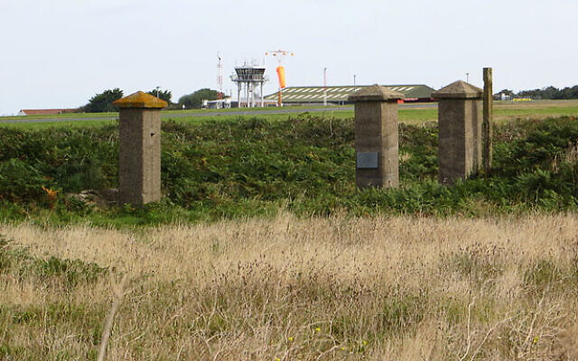
The old gate posts to Lager Sylt on the island of Alderney, 2012. (CC BY-SA 2.0/ John Rostron)
“That has been fairly central to some of the arguments around the importance of the site,” she says. “It’s made it in some ways easier for people to ignore the history of what happened at Sylt because if you can’t see the site and if there’s nothing there to see, obviously that makes it easier to ignore its history.”
There is, the archaeologist says, “a long legacy” which goes back to immediately after the war when the British government was “not necessarily keen to even acknowledge that these camps existed on British soil.” That legacy also meant that a lot of archive material remained classified for many years.
As more and more evidence comes to light it becomes more painful
Sturdy Colls accepts that the subject is a difficult one for many islanders. “As more and more evidence comes to light it becomes more painful for some people to keep having this period of history dug up over and over again metaphorically,” she says.
She also recognizes there has been an effort on the part of some journalists and writers to “sensationalize the history of what happened on Alderney.”
“Part of the reason I started the project in the first place was because I wanted to go back and review all of the archival materials and then look at the physical evidence to try and cut through some of the myth and conjecture that had built up,” the archaeologist says.
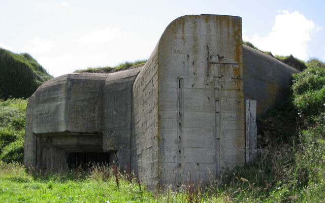
Bunker on Alderney, likely built by slave labor from Sylt and the other camps. (Andree Stephan/ CC BY 3.0/ via Antiquity Publications)
Sturdy Colls is careful not to suggest her team’s latest research is full of revelations. “I’m not saying that everything in the paper has never been written anywhere before,” she says. “Clearly, a lot of people gave testimony about this, but I really hope that the archaeology validates those testimonies in many ways and it also fills in some of the gaps, because there are some things that people didn’t say in the testimonies either because they were never asked or they didn’t think it was important.”
In all, the archaeological team recorded 32 surface features at Sylt, including four boundaries, five structures within the SS sections, two in the camp commandant’s section, and 21 in the prisoners’ sections.
“Notable structures hidden under vegetation in the prisoner area include the toilet block and bathhouse, stables, and a kitchen with an accompanying subterranean cellar,” the paper says. “Remains of the SS canteen, workshops and guardroom were revealed in the SS area. Sentry posts, gateposts and the remnants of the camp fences also survive. The lidar and geophysical survey data reveal extensive evidence surviving beneath the ground’s surface, including the foundations of prisoner and SS barracks, the sickbay and construction office.”
Using aerial photography and geophysical data, the research also tracks how Sylt evolved in a short period from a small forced labor prison into a much larger concentration camp. That development is illustrated in the research by 3D reconstructions.
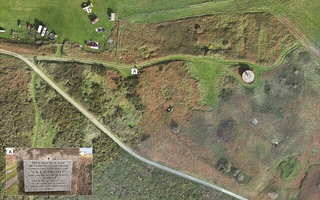
Drone shot of the remains of Sylt; Inset: memorial plaque at the site. (Centre of Archaeology; Staffordshire University; FlyThru/ Courtesy Antiquity Publications)
The human story
But it is the prisoners’ story — one of “hard labor, poor rations and harsh punishments,” as the paper puts it — that Sturdy Colls wanted to lay at the heart of the research.
“I was really trying to convey the human story,” she says. “A lot of my work, particularly as an archaeologist, has to be very scientific, but what I was trying to do with this really — and I try and do with all the work that I do in relationship to the Holocaust and genocide — is to show that we’re not just talking about bricks and mortar, we’re not just talking about numbers here. We’re talking about real people, and the way that those buildings were constructed, it made such a difference to people’s lives.”
That desire to weave together the relationship between the architecture of Sylt, the unforgiving landscape, and the terrible experience of the inmates is evident throughout the research.
It records, for instance, the manner in which, while the number of prisoner barracks doubled during this time, the camp population quintupled from 100-200 to over 1,000 inmates. Today, the wooden barracks are long gone, but traces survive as shallow depressions, with buried concrete foundations and stairs leading down from ground level.
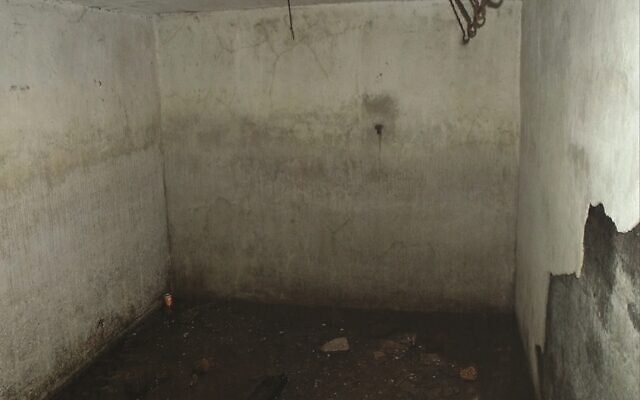
The prisoner kitchen cellar at the Sylt concentration camp on the island of Alderney. (Centre of Archaeology, Staffordshire University/ via Antiquity Publications)
Mapping out the barracks — which were exposed to the coast’s windy weather — graphically corroborates witness testimony of acute overcrowding. Each barrack, which housed roughly 150 men, allowed for less than 1.5 square meters (4 feet by 4 feet) for each person.
The size of the foundation of the prisoners’ kitchen — less than 20 meters by 6.03 meters (65 feet by 20 feet) — tells a story which, again, confirms later accounts of pitiful rations and lack of food. As Sturdy Colls says: “Obviously, they never really intended to feed them properly, otherwise they would have built a bigger kitchen.” The toilet block, which was uncovered in 2013, was also undersized and basic, as was the simple wooden building which housed the sickbay.
The archaeological survey draws out the contrast between the prisoners’ facilities and the comfort enjoyed by their SS guards. Many SS structures, for instance, were constructed from reinforced concrete. To protect them from the island’s harsh weather, and possible air raids, SS buildings were surrounded by stone walling and had foundations dug below ground level. The SS also put their horses in stables — whose foundations and a concrete trough survive in good condition — which were better constructed than the prisoner buildings.
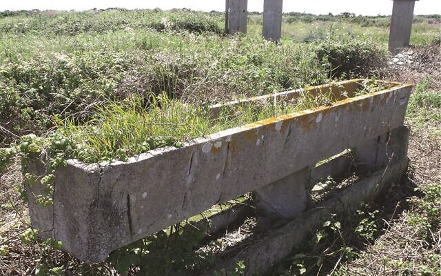
Stable block at the Sylt concentration camp on the island of Alderney. (Centre of Archaeology, Staffordshire University/ via Antiquity Publications)
The archaeologists also investigated a tunnel which traveled from inside a prisoner bathhouse to just behind the commandant’s Tyrolean-style villa outside the camp walls. Electric lighting in the tunnel, whose existence has long been documented, indicates that it was well-used, but its purpose remains a mystery. Speculation has ranged from suggestions that it was a bomb shelter to the idea it was a space through which women could be taken into a brothel within the villa.
There is, says Sturdy Colls, a “weird contrast” between the the fact that the camp was so heavily guarded and this apparent weak spot where there is seemingly access between the commandant’s house and the prisoner area at the camp.
The researchers also explored the “heightened security measures” which were constructed — including barbed wire fences and watchtowers — as Sylt was transformed into a concentration camp.
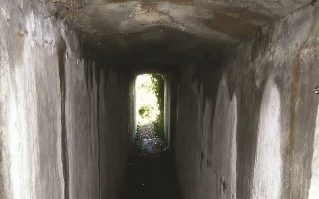
The tunnel which connected the Sylt concentration camp commandant’s house to the camp proper. (Centre of Archaeology, Staffordshire University/ via Antiquity Publications)
“The nature of the security of this camp was incredibly strong in terms of the number of guards, but also in terms of the way that the camp was built given that there was nowhere to go when the prisoners escaped,” says Sturdy Colls.
Indeed, the fact that any escaped prisoner would encounter minefields, steep cliff edges and the sea makes clear that the security was, in part, intended to exact a psychological toll on those incarcerated behind it.
The nature of the security of this camp was incredibly strong given that there was nowhere to go when the prisoners escaped
As the archaeologist says: “The architecture of the camp and the number of guards was a way of making very clear to those prisoners that the SS was in control of every moment of their daily lives.”
The SS also used the security fences to taunt the prisoners — encouraging them to attempt to escape through them, and then shooting them when they did — and to inflict brutal punishments upon them.
Illustrative: Archeologist Caroline Sturdy Colls oversees excavations conducted at the mass graves area of Treblinka, the former Nazi death camp in eastern Poland. (Courtesy)
“I hope one of the key things about the article is that it shows that these weren’t just fence lines, these weren’t just buildings and wood and bricks and mortar,” says Sturdy Colls. “These were places where obviously the prisoners really did experience terrible atrocities, and a lot of that was connected to the way in which the camp was built and the way in which they were guarded within the camp.”
The scale of the horror perpetrated on Alderney is hotly debated. Official accounts after the war figured that less than 400 of the slave laborers died on the island. Seventy years on, though, some historians and military experts suggest the workforce and the death toll have been grossly underestimated.
Colonel Richard Kemp, Britain’s former commander in Afghanistan who has carried out detailed research into the Nazis’ reign of terror on the island, has, for instance, suggested the number of slave laborers who perished on Alderney is at least 40,000.

Illustrative; German WWII bunker ‘The Odeon’ in Alderney. The bunker is about three to four stories high and has an anti-aircraft emplacement at the back. Alderney is said to have been the most heavily fortified of the Channel Islands. (CC-SA-Tim Brighton)
Sturdy Colls says that coming to an official figure for the death-toll on Alderney is “very difficult.” She believes at least 700 slave laborers died, while labeling the figure a “very conservative estimate.” However, she continues, there is “no evidence that I’ve found in 10 years of archive research to suggest that numbers in the tens of thousands of deaths are in any way credible whatsoever. There is no evidence to suggest that that many people were even sent to Alderney.”
Her next project is a book on Alderney in which she is attempting to trace the stories of those who lived — and died — under the occupation.
“I think it’s very important to not only investigate that physical evidence and the source material,” Sturdy Colls says, “but to make sure in doing so we’re able to say something about those individuals to remind people that this isn’t something that just happened to collective groups of people.”
“Every one of those victims,” she says, “had their own stories to tell.”
Comments:
Comments:
Inka Dupont
My parents, my relatives, and most of the friends they had, all where P.O.W. in Japanese concentration camps in Indonesia. That was also not very well known to people but it happened. This story reminds me of that.
I think it's appalling what people can do to other people. And history doesn't record it.
I think it's appalling what people can do to other people. And history doesn't record it.
Roger Eden
There is no European country that did not have willing and enthusiastic participants in the Holocaust. They weren't Nazis, many were anti-German. Even UK citizens. On Jersey, prior to the arrival of the invading Nazis, the British Governor, sent British Policemen to round up the few Jews, writing an obsequious letter (still on the archives) that "he had the honor to inform the incoming General that he has collected the Jews...). They were murdered. He thought he was currying Nazi favors. Didn't help. The Governor was knighted at the end of the War.
Chandramouli Donti
The British and other Europeans invaded so many countries all over the world and destroyed the local cultures, economy and looted them. In no way they are better than German devils. All are same. Shame on humanity.
Miche Norman
Not true - the British had concentration camps all over the UK in the first and second world wars - some of them run on lines very similar to those that Dachau was run under complete with kapos.


